
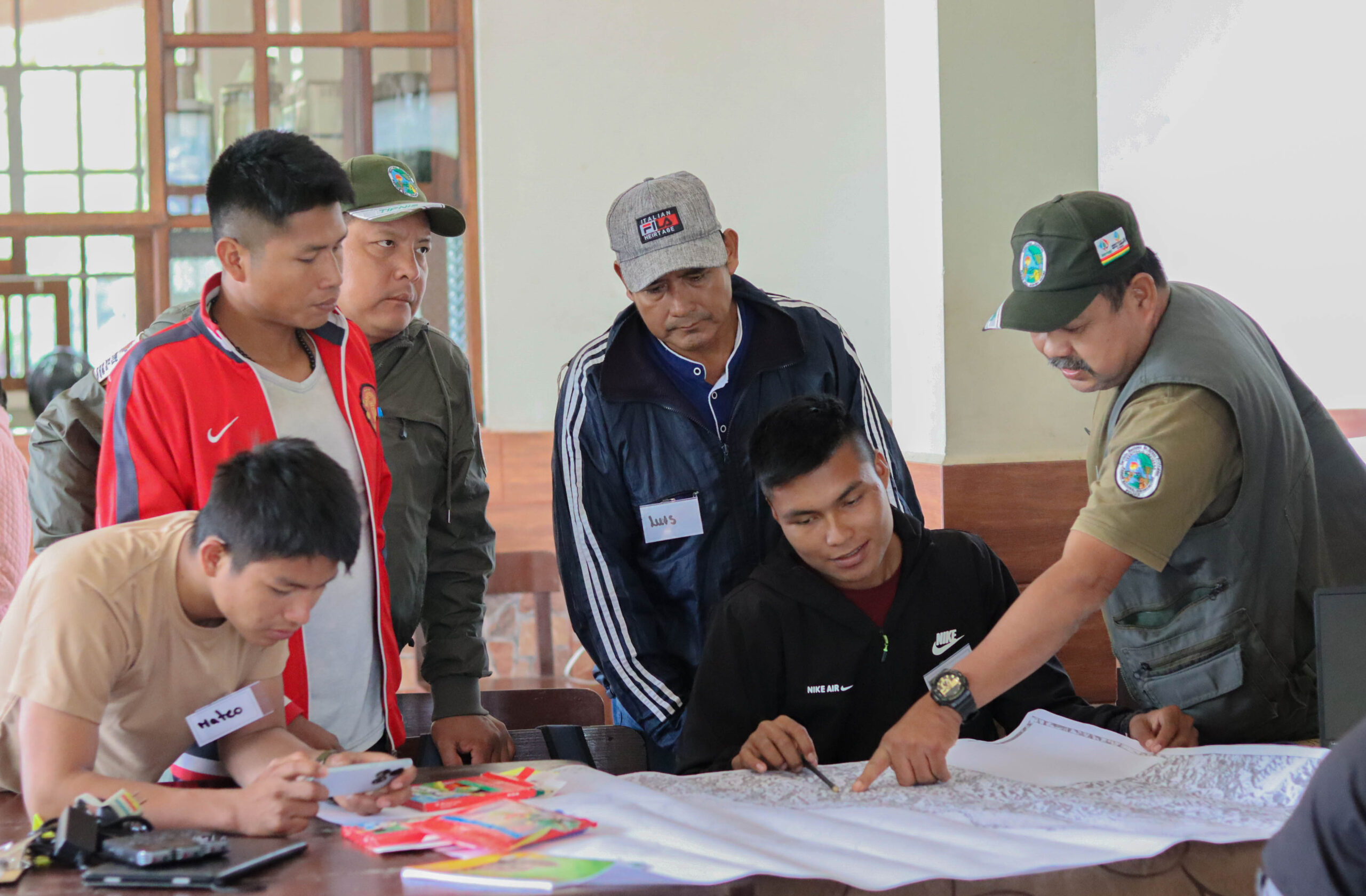
In 2024, communities in the southern part of the Isiboro Sécure Indigenous Territory and National Park (TIPNIS) implemented a Territorial Satellite Monitoring initiative, a tool that enabled them to confirm the threats faced by the Yuracaré, Mojeño-Trinitario, and Tsimane Indigenous peoples of the Indigenous Council of the South (CONISUR) due to external actors, both private and public. The main threats to the territory include alluvial mining, the expansion of illegal coca cultivation, and land invasions affecting Indigenous communities.
Isiboro Sécure Indigenous Territory and National Park (TIPNIS) is located between northern Cochabamba and southern Beni. It also spans the Chapare and Ayopaya provinces in Cochabamba and the Moxos and Marbán provinces in Beni. Its natural boundaries, established in 1965 and expanded in 1990, are defined by the Natusama, Sécure, Isiboro, and Chipiriri rivers, as well as the Sejeruma and Mosetenes mountain ranges.
TIPNIS holds a dual status as both a National Park and an Indigenous Territory. It has been home to three Indigenous ethnic groups—the Yuracaré, Mojeño-Trinitario, and Tsimane—who are distributed across 74 communities. Their livelihoods depend on the sustainable use of natural resources, including hunting, fishing, gathering, timber extraction, agriculture, and livestock farming. Covering an area of 1,236,296 hectares (approximately 12,363 square kilometers), TIPNIS is renowned for its rich biodiversity and protects 857 animal species and around 3,500 plant species.
Throughout its history, TIPNIS has been—and remains—a contested territory. Satellite-based territorial monitoring has uncovered alarming evidence of the various threats and rights violations faced by the Indigenous communities in this vast region. Park rangers and Indigenous territorial guardians work tirelessly to defend and protect TIPNIS, despite a severe shortage of financial resources, equipment, and logistical support, which hinders their ability to combat land invasions, illegal logging, deforestation, poaching, and turtle egg trafficking.

Pressures on TIPNIS
Despite the legal protections of its dual status, TIPNIS remains a highly coveted and constantly threatened territory, targeted by external actors such as intercultural settlers (colonizers), loggers, poachers, and large-scale infrastructure projects. These actors seek to exploit its natural resources, often taking advantage of public policies that promote an extractivist development model.
In 2011, during the VIII Great Indigenous March in Defense of TIPNIS, Territories, Life, Dignity, and Indigenous Peoples’ Rights, the Yuracaré, Mojeño-Trinitario, and Tsimane communities strongly opposed the construction of a road from Villa Tunari to San Ignacio de Moxos, planned to cut through the core zone of their territory.
The public sector, specifically the governments of Beni and Cochabamba, continues to insist on reactivating the Villa Tunari – San Ignacio de Moxos highway megaproject, which was rejected for the second time during the Corregidores’ Assembly in March 2023. The highway is a subject that is consistently used for political leverage by both subnational and national public authorities. This is reflected in the constraints CONISUR-TIPNIS communities face in the implementation of projects and the provision of services such as education and healthcare.
Regarding the presence of foreign actors (particularly Colombians and Peruvians), there is a growing trend of men seeking marriage with Indigenous women as a means to gain legitimacy and establish a foothold in the territory. Meanwhile, mining cooperatives are also encroaching on Indigenous territories and the national park, where some operations are located just a few kilometers from the core zone. A similar situation is occurring across much of the Bolivian Amazon, where cooperatives are invading Indigenous lands, violently seizing riverbanks, violating Indigenous rights.

Territorial Satellite Monitoring
These scenarios of territorial and collective rights violations in Indigenous communities prompted the corregidores of CONISUR-TIPNIS to explore technological tools for effective territorial monitoring. In this context, the original authorities decided to develop a territorial monitoring system based on high-precision satellite imagery, which allowed for: 1. Tracking the territory to gather evidence of potential violations; and 2. Updating territorial zoning with the aim of collaboratively creating a territorial management or life plan.
Satellite monitoring is a tool that provides high-quality information on the use, exploitation, and risks related to the natural resources of the territory. On the one hand, it serves as a preventive measure against potential rights violations, as it reports on both natural events and human activity that requires timely intervention. On the other hand, by facilitating the reporting of harmful acts against the rights of Indigenous Peoples, whether committed by individuals or state authorities, before administrative or judicial bodies, and demanding the restitution and enjoyment of those rights it is restorative.
The satellite monitoring training process involves the participation of Indigenous territorial guardians from CONISUR, community-elected youth, and park rangers from the National Protected Areas Service (SERNAP). One of the primary concerns of the chiefs and corregidores of CONISUR was the reports of land invasions by intercultural settlers who conduct slash-and-burn activities and land clearing for coca cultivation. In this regard, the 2020 Annual Coca Monitoring Report, published by the United Nations Office on Drugs and Crime, revealed the identification of 1,373 hectares of coca crops within Polygon Seven that year. More alarmingly, 27 hectares were found within the Indigenous territory, where coca cultivation is prohibited.
Threats and Vulnerabilities Identified in TIPNIS
Satellite monitoring specifically enabled the identification of forest cover and tree cover loss, the presence of fires or heat sources generated within the territory, as well as data on deforestation, land invasions, and road openings.
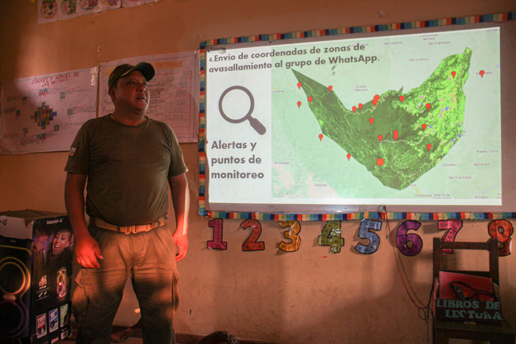
During training conducted in 2024, Indigenous monitors enhanced their ability to send coordinates related to human-induced events or irregular natural phenomena in areas deemed vulnerable, based on the level of care and protection needed for each area. Using these events, a criteria-based classification of vulnerable zones was determined: high-risk for those in core zones, medium-risk for those in resource-use zones, and low-risk for those in traditional-use zones. Based on these criteria, the monitors identified and sent coordinates for vulnerable areas, which are considered as threats to the territory.
Among the events threatening which have raised significant concern among communities in the south, in TIPNIS territory, are alluvial mining activities, the expansion of coca producers from the municipality of Cocapata (Ayopaya province) into the TIPNIS core zone, and land invasions by intercultural settlers in Polygon 7 which lead to violations of agreements by the settlers.
Specific Threat Hotspots
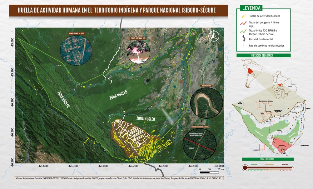
Thanks to satellite monitoring and the work of Indigenous monitors, the following conflict hotspots were identified:
1. Alluvial Mining in the Altamachi River
In 2024, land clearing and the construction of roads for heavy machinery were observed just 5 kilometers from TIPNIS, along the Altamachi River, for alluvial mining activities. This threatens to contaminate the downstream communities. The coordinates of this area were sent to the satellite monitoring group, and park rangers from SERNAP successfully verified them.

2. Incursion into the Santo Domingo Zone
in Santo Domingo, in the northern part of the territory, a large area of land clearing was detected just 3 kilometers from the TIPNIS boundary, a direct threat to access to the core zone. The coordinates of this incursion were also sent to the satellite monitoring group.

3. Breach of Agreements: “Red Line of Polygon 7”
Monthly satellite images reveal that some of the plots (chacos) of intercultural settlers have crossed the red line, violating the established protection agreements and worsening the situation in the area.
3.1 Land Invasion in the Sindicato Bustillos Zone
The Bustillos syndicate has repeatedly expanded its coca cultivation near the river, increasing pressure on TIPNIS. According to the monthly satellite monitoring, these illegal activities occur frequently, deteriorating the natural environment and threatening the traditional practices of Indigenous communities that rely on the river for their livelihoods. It has also been confirmed that the Red Line of Polygon 7 has not been respected, with the boundary being exceeded in the past year, further aggravating the situation in the affected area.

3.2 Land Invasion in the Sindicato Primavera Zone
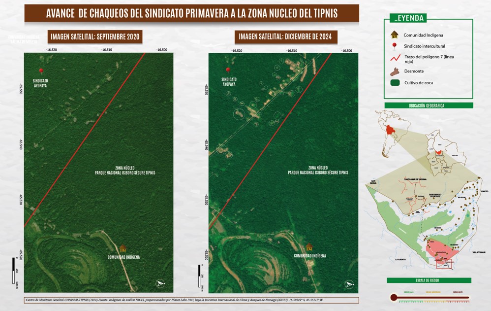
El Sindicato Primavera ha desarrollado cultivos de coca que impactan directamente sobre el TIPNIS. A pesar de los esfuerzos de la comunidad indígena por proteger su territorio, estas actividades siguen generando un impacto negativo, tanto en el entorno natural como en la estructura social de las comunidades. Además de los cultivos, el monitoreo satelital ha revelado una expansión preocupante del territorio cocalero, con la posibilidad de que se excedan los límites del Polígono 7.
3.3 Land Invasions in Polygon 7
The map suggests a rapid growth of settlements and coca cultivation in TIPNIS, driven, according to testimonies, by external actors. This is likely changing the way of life and thought among ndigenous communities that undermines their traditional practices and alters the social and territorial dynamics of the region.

Monitoring as a Tool for Territorial Protection
This set of threats and violations of the collective and territorial rights of TIPNIS communities clearly reveals economic interests that drive various internal and external actors to the territory.
The information collected through satellite monitoring regarding “vulnerable areas” emphasizes the need to find defense mechanisms to address existing conflicts and to pproach them from a comprehensive perspective based on the collective rights recognized in Articles 2 and 30 of the Political Constitution of the State, as well as the international standards included in the constitutional block, such as economic, social, cultural, and environmental rights (DESCA), that protect Indigenous communities.

Sergio Vásquez Rojas is the Executive Director of CENDA and a specialist in Indigenous Law and Agroenvironmental Law.